


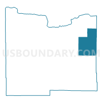
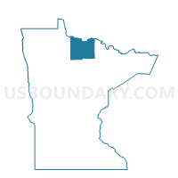
Beaver-Meding-Ray Precinct, Koochiching County, Minnesota
About
Outline

Summary
| Unique Area Identifier | 602796 |
| Name | Beaver-Meding-Ray Precinct |
| County | Koochiching County |
| State | Minnesota |
| Area (square miles) | 180.28 |
| Land Area (square miles) | 179.53 |
| Water Area (square miles) | 0.75 |
| % of Land Area | 99.58 |
| % of Water Area | 0.42 |
| Latitude of the Internal Point | 48.33052140 |
| Longtitude of the Internal Point | -93.21032680 |
Maps

Graphs
Select a template below for downloading or customizing gragh for Beaver-Meding-Ray Precinct, Koochiching County, Minnesota


Neighbors
Neighoring Voting District (by Name) Neighboring Voting District on the Map
- Cingmars Precinct, Koochiching County, MN
- Cross River-Dentaybow Precinct, Koochiching County, MN
- Kabetogama Twp. Voting District, St. Louis County, MN
- Koochiching Poll 1 Voting District, Koochiching County, MN
- Rat Root Precinct, Koochiching County, MN
- Unorg. Prct. 21, St. Louis County, MN
Top 10 Neighboring County Subdivision (by Population) Neighboring County Subdivision on the Map
- Rainy Lake UT, Koochiching County, MN (4,048)
- East Koochiching UT, Koochiching County, MN (355)
- Northwest St. Louis UT, St. Louis County, MN (301)
- Kabetogama township, St. Louis County, MN (135)
Top 10 Neighboring Unified School District (by Population) Neighboring Unified School District on the Map
- St. Louis County School District, MN (17,844)
- International Falls Public School District, MN (10,163)
- Littlefork-Big Falls School District, MN (1,659)